The Upper Region
The upper region is only accessible if the Palmer Lift it open, unless you are prepared to spend a couple of hours climbing to the 8,500′ level.
From the top of Palmer, you need to traverse directly to the west (toward Portland). There have been times in past years, when the Timberline crew helpfully dug out a passage under the Palmer lift right next to the upper station. But, this has not happened in recent years.
It seems Timberline would prefer that people climb up and over the top station of the Palmer lift. This is doable, but it is also quite a lot of work, and at that altitude you will be catching your breath. This climbing is also time-consuming and not really necessary. It could potentially also be dangerous if you slip and lose your balance when you are right above the lift building. You might lose your footing, slide down, and fall onto a solid flat surface from a potentially life-threatening height.
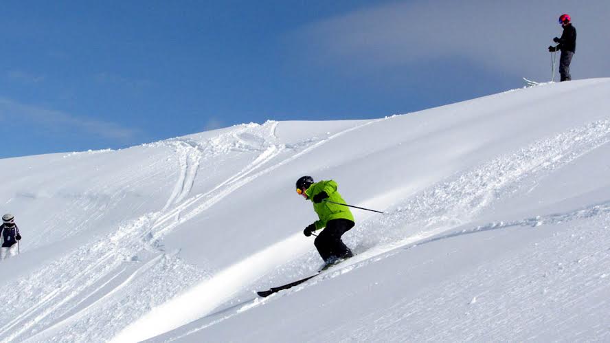
So, the easiest way is to ski down the main Palmer run, close to the lift, for just a few turns, until you see an opening on your right where you can cross over to the other side under the lift.
Once on the west side of the lift, you are already out of bounds. The terrain there is basically the same as on the inbounds side, same steepness, but the snow is ungroomed. Depending on the conditions, sometimes the ungroomed snow is actually easier to ski than the groomed but icy or slushy snow. So, you can easily play in the ungroomed snow for a while, always within sight of the lift, and you can always traverse back to the groomed slope if the snow turns heavy.
Zig Zag Canyon
From the top of the Palmer lift, keep traversing westward, toward an imaginary point below Illumination Rock, until the natural curvature of the terrain takes you just out of sight of the Palmer lift. This traverse doesn’t have to be totally horizontal (as is needed to get from the Magic Mile to Little Zig Zag canyon). Here, you can actually trade some vertical to get some speed and make the traverse faster and easier.
Eventually, you will reach Zig Zag Canyon. Depending on how much vertical you lost during the traverse, the canyon might be right in front of you, or slightly below you.
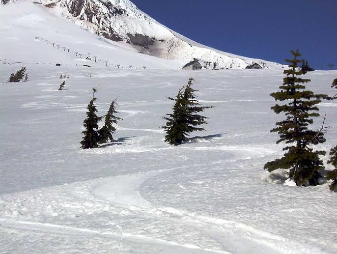
Zig Zag Canyon actually starts with two branches (the east and the west branch) that eventually merge into one. The west branch starts just a bit higher up on the mountain, so that is the one you will encounter first when approaching it from above or from the Palmer snowfield.
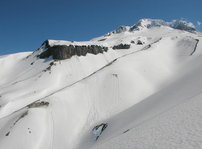
Don’t go there on a foggy day with low visibility. The entrance to Zig Zag Canyon is surprisingly steep and not very visible from a distance, until you are almost at the canyon’s edge. Zig Zag is also the largest of the three main canyons mentioned above. The proportions can be a bit intimidating. If anyone claims that Timberline doesn’t offer enough challenge, they haven’t visited Zig Zag Canyon yet.
Zig Zag Canyon is Oregon’s answer to Jackson Hole’s Corbet’s Couloir, in the sense that it is a place to prove you manhood!!!
Attention intermediate folks! Don’t feel too intimidated. There is also a big difference. Corbet’s Couloir is an all-or-nothing proposition. But the beauty of Zig Zag Canyon is that you can choose your level of difficulty by simply selecting the place you enter. The farther west you go, the steeper the entry to the canyon. The easiest way to enter the canyon is from the east side, as Dave Misitano demonstrates here:
It gets even easier if you choose not to enter the canyon at the very top, but to ski a bit further down along one of its eastern flanks that gradually enters the canyon.
Have a camera read to take a photo of yourself and your friend(s) in front of Mississippi Head, the spectacular rock face on the west side of Zig Zag Canyon a little lower down from the place you should be exiting the canyon. Did you know that a World War II bomber plane crashed into Mississippi Head on a practice mission in 1949? There is a plaque commemorating the event inside the climbers’ registration room at Timberline’s day lodge.
The most important thing about Zig Zag Canyon is knowing where to exit. On most days, you will see tracks of people who have been there before you, so simply follow those. There are 3 ways to handle the exit:
1. The Easy Way
Make just a very few turns at the top and exit sharply left, hugging the relatively steep side wall of the canyon. Then immediately cross the east branch of the canyon in a similar fashion, by making just a few quick turns and exiting eastward toward the ski lifts.
2. The Riskier Way
Exit the west branch quickly, as above, but then enter the east branch and make many turns in it, finally exiting it at a point slightly lower than Mississippi Head, but still long before the tree line. Yes, it’s possible to ski that much into the east branch, and at this point you are still safe. The danger comes when you traverse farther east and come across Little Zig Zag canyon. The only way to cross Little Zig Zag is to first enter it, and that means jumping into it over the sometimes overhanging cornice. Will you have the guts to do that? There is no easy way around it, because that whole western edge of Little Zig Zag is corniced for what seems to be miles. Climbing up to the start of the canyon is too much work and climbing down seems like the cornice never ends. It does, but way too low to get back to the lifts. There are times when it’s not so bad, but why risk it?
3. The Suicidal Way
Do not ever even think of attempting this. You will regret it. If you ski too low into the west branch of Zig Zag Canyon, the ridge separating it from the east branch won’t let you exit the canyon in time, as you can do from the east branch. Besides, regardless of which branch you enter, resist the temptation to continue skiing this canyon. The snow is great and the slope is wide open and inviting. But, if you go too far down, there is no easy way out. Zig Zag Canyon is like the roach motel. You can check in, but you can’t check out. The wide open slope eventually narrows down to a narrow canyon with extremely steep walls on both sides. You cannot possibly climb out of it, and the bottom of the canyon eventually becomes a raging river, the Zig Zag River, which in principle should take you back to civilization, if only there was a way to safely and comfortably ski or walk down its banks.
If you want to find out firsthand what it might be like to follow the path of Zig Zag River downhill, try it the relatively safe way by hiking it in the summer. Start from below and work your way up. From highway 26, just before the big curves heading to Government Camp, turn left onto Kiwanis Camp Road (Road 39) and within the next mile or so park the car somewhere near the Paradise Park trailhead. The noisy river you’ll find there is the Zig Zag River. Try hiking upstream, and you will soon discover why it’s not a good idea to try to ski that way in the winter.
So, back to skiing it from the top. You first dip into the west branch, then you dip into the east branch, making just 3 or 4 turns in each. What next? Continue diagonally in a south-east direction, back toward the lifts. Always remember to look toward Mt. Jefferson in the distance. Don’t follow the fall line. Follow Mt. Jefferson.
Pretty soon, you will see the building that houses the upper end of the Magic Mile lift. If you look down the slope, you will see another, smaller canyon below. That is Little Zig Zag canyon. At some point, you will need to make a decision as to what you want to do next:
- Traverse to the top of the Magic Mile, and you can catch Palmer chair.
- Turn down toward Little Zig Zag canyon and ski it for a while. If you exit it before the tree line, you will then again have two choices: either ski back to the lower end of the Magic Mile lift, or hit the Mountaineer trail meadow (slightly before the Stormin’ Norman lift) and then ski past the invisible Timberline Cabin and follow the yellow markers back to the Stormin’ Norman or Jeff Flood lifts.
Last modified: May 6, 2014