The newly discovered Mount Hood Fault Zone adds an admittedly ominous but also quite fascinating layer of underlying complexity to one of the most climbed, skied and beloved mountains on the planet. So what is the Mount Hood Fault Zone? Where exactly is it located? How was it discovered, and what can we learn from the research?
Here is a quick Q & A synopsis of some key findings about the seismic state of Mount Hood:
1. Who did the research?
A team of scientists led by Ian P. Madin of the Oregon Department of Geology & Mineral Industries and Ashley R. Streig of Portland State University.
2. How did they make their discovery?
In a word, Lidar. Light detection and ranging, a combination of 3-D scanning and laser technology, is one of the great advances of the past century. Lidar’s increasingly sharp and high resolution imagery has helped archaeologists find lost civilizations buried in the planet’s deepest jungles, along with many other applications in development. Madin, Streig, and their research colleagues used Lidar to collect eight deep data points per square meter over much of Western Oregon. The team analyzed the data using 2-D and 3-D technology, then followed up with field research and detailed mapping.
3. What is the Mount Hood Fault Zone?
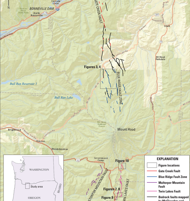
The fault zone consists of four fracture lines or fault segments that result from plate tectonic activity.
4. Where exactly is it located?
The fault segments extend from Clear Lake to the south to the Columbia River to the north (see map below). They are, from south to north: the Twin Lakes Fault, the Multorpor Mountain Fault, the Blue Ridge Fault Zone, and the Gate Creek Fault. The area directly under Mount Hood could not be mapped with Lidar due to its (geologically) recent history of eruptions, glaciation, and debris flows.
5. Where did the researchers find evidence of past seismic activity?
Researchers found evidence of a past earthquake within the Blue Ridge Fault Zone on the north slope of Mount Hood.
6. How long ago did the past earthquake happen within the fault zone?
It’s very hard to pinpoint when a past earthquake occurred, but geologists can arrive at defensible estimates using accelerator mass spectroscopy radiocarbon data. They estimate the earthquake rocked the Blue Ridge Fault Zone somewhere between 13,540 and 9,835 years ago
7. How strong was it?
The research team estimates it was a magnitude 6.8-6.9 quake. The Richter scale is logarithmic measure of seismic intensity, so small numerical differences can mean a lot. A magnitude 6 earthquake is no big deal; a magnitude 9 quake would be absolutely terrifying.
8. How worried should we be?
It depends on how you look at it. On the one hand, it doesn’t seem wise to ignore a newly discovered fault zone 60 miles from a metropolitan area of 2.5 million people, in a recreation zone that attracts 4 million annual visitors. At the same time, a once-every few-thousand-years event is inherently rare, right? Especially when we already have the “mega-thrust” Cascadia Subduction Zone and its attending tsunamis to worry about – not to mention global climate chaos.
Still, there are legit reasons to be concerned about Mount Hood Fault Zone, and they definitely seem to merit further study. As the authors point out:
“The fault zone poses a serious seismic threat to the cities of Hood River, Odell, Parkdale, White Salmon, Stevenson, Cascade Locks, Government Camp, and the Villages of Mount Hood. In addition it may pose a threat to critical regional infrastructure including the City of Portland’s Bull Run Drinking water system, storage reservoirs operated by Portland General Electric and rail transportation corridors in the Columbia Gorge, and the U.S. Army Corps of Engineers power generation facilities at Bonneville Dam.”
So yes, it’s probably worth keeping a close eye on the Mount Hood Fault Zone, and learning as much about it as possible.
Cited Source: Field-Trip Guide to Mount Hood, Oregon, Highlighting Eruptive History and Hazards, Scientific Investigations Report 2017–5022–G, by Ian P. Madin, Ashley R. Streig, William J. Burns, and Lina Ma.
Last modified: November 28, 2018